landscape

Hampstead Heath - Sandy Heath and midnight iris

Hampstead Heath is a woodland and grassland area located in north-west London. The Heath is covering 320 hectares and it takes approximately 3 hours to walk around its circumference. Within this large parkland is to be found 18 ponds. However, in this blog I focus on one pond, so small, that it is not included in the official count and does not have a name either.

Sandy Heath

Sandy Heath

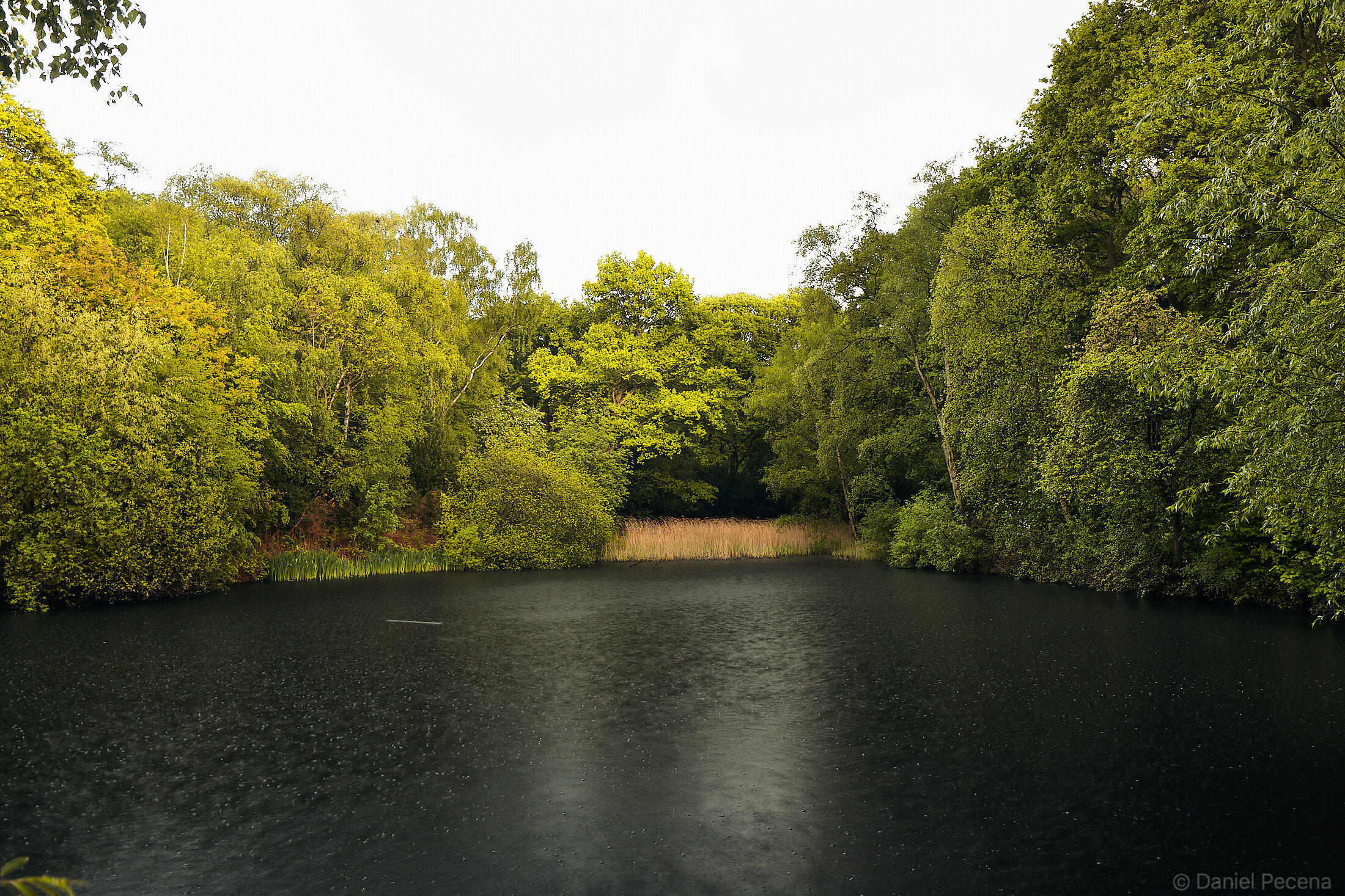
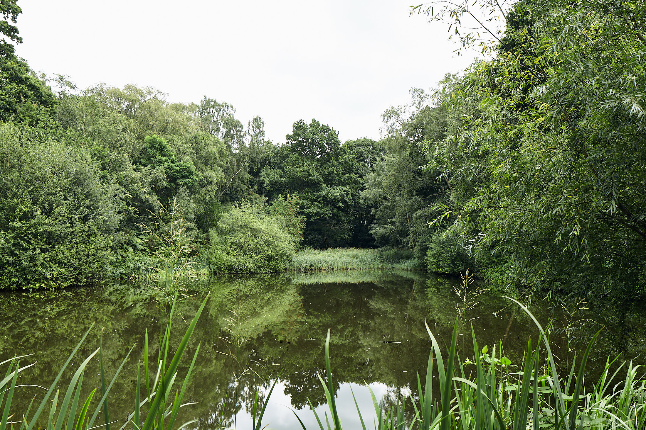
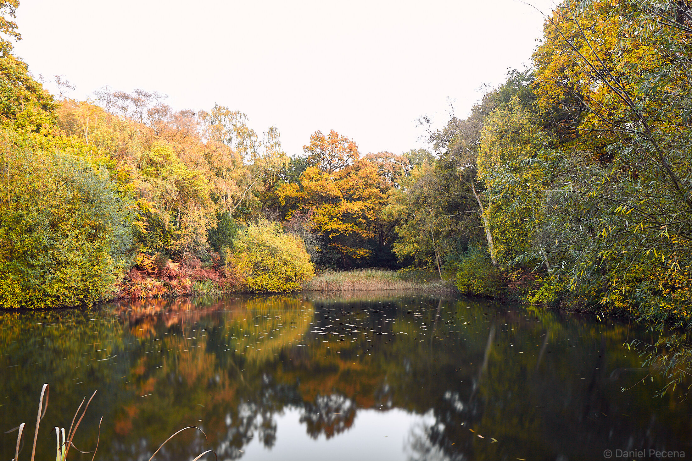
The spring was slowly beginning in March and I first noticed it on the Heath when green blades of iris leaves started to shoot up near the pond (since March I visited this place many times and as I noticed a pair of ducks living here, I started to call it Two Ducks pond). This (Two Ducks) pond in Sandy Heath area is between Two Tree hill with its two 300 years old oaks and Constable pine which is the oldest pine tree on the whole Heath. As the name suggest the pine tree has already been here in the time when the famous landscape painter John Constable lived and worked in Hampstead in 1820’s. That was at the time when this part of Heath wasn’t woodland yet. An interesting fact also says that people who wanted to travel through this area had to pay toll at the Toll Gate House which is still standing next to Spaniard’s Inn pub and is now a listed building.

The underlying soil in this part of Heath is rich in Bagshot sand. This granular material was laid down in shallow coastal seas about 50 millions years ago and then slowly distributed by Bagshot river flowing from south-west England across Salisbury Plain to deposit thick river sands in London basin. The soil particularly suits growth of vegetation such as gorse, heather, birch and pine trees. Today there is a secondary woodland with great prevalence of oak, beech and hawthorn trees as well.

When Sir Thomas Maryon Wilson, the 8th baronet inherited most of the Heath from his deceased father (the 7th baronet) in 1821, he wanted to build on it but was frustrated by certain stipulations in his father’s will as well as local oppositions. His plans in building up estate with 28 villas was stopped by parliament that pronounced the project not in the public interest. The only materialized structure from his efforts on his land was the Viaduct built in 1840’s which is still standing in East Heath.

Instead of building on Sandy Heath he used the sand as a building material and was selling up to 30 carts a day to the Midland Railway for a new track out of London St Pancras. Due to the high iron content, the sand is not suitable for mortar making and therefore it was used only for railway or road building and later for filling in sandbags during two World Wars.

Woodland, full moon, Sandy Heath, Hampstead Heath, London.jpg

Sandy Heath - April full moon

Sandy Heath - May full moon and midnight runner

Sandy Heath - May full moon and midnight runner

I have been returning to Sandy Heath, now full of trees, day and night since the beginning of spring. During the day this area has been busy with people enjoying sunshine, walking their dogs and experiencing outdoors. In April I spotted six new-born ducklings in nearby bigger pond, jaybird bathing in smaller ponds and other animals such as rabbits, foxes, frogs, bats and immense quantity of birds and insect. I also came to photograph the (Two Ducks) pond during the April and May full moons. There was no breeze but the forest wasn’t silent. All sort of animal noises complemented the long exposures and the play of light and shadows caused by moonlight getting through the trees was something poetic to behold. In the second half of May the yellow water irises at (Two Ducks) pond were finally in bloom. The act of opening their flowers to insect pollinators don’t last long. Several days in and it was over. During this blooming time however, the yellow water iris produces a lot of nectar. In fact, according to survey done by AgriLand project in 2011-2012, researchers from Bristol University identified that of all flowers, yellow water iris (Iris pseudacerus) has second greatest nectar production per micro-gram of sugar per day in the UK (the greatest nectar production per day is by Himalayan balsam (Impatiens glandulifera) which is a non-native species in the UK).

The summertime is slowly approaching and as always in summer months few of these small ponds around here will be covered by a thin film of green algae. The ducks and other wildfowl will be floating in water creating lines on the surface behind them. Life on this patch will go on, and hopefully undisturbed.

Sandy Heath - midnight illuminated

Sandy Heath - midnight illuminated

Sandy Heath - iris flower (iris pseudacorus) at midnight

Sandy Heath - iris flower (iris pseudacorus) at midnight


Brexit - Political Landscape

London_Parliament Hill_Before Brexit / After Brexit_31.1.2020

The land of what is now the United Kingdom (UK) has been located on island(s) for at least 8000 years. The city of London was founded as Londinium by the Romans nearly 2000 years ago in the Thames valley.

From long-term historical viewpoint, the so called Brexit (UK leaving political and economical institution – the European Union) is most likely a small blip of an event. However, this recent political exit has been process stretching over three and half years, culminating on 31.1.2020 at 11pm GMT when the UK symbolically left the EU. Nevertheless the political process still continues...

I walked up to Parliament Hill in Hampstead Heath to observe this event and take images of London skyline before the exit and after the exit.


Hampstead Heath – Leg of Mutton pond

Hampstead Heath in north-west London is an expansive area of woodland, open fields and fresh air. It contains 18 ponds that are scattered across the Heath. I have chosen one of these ponds and its surroundings to illustrate the ideas of seasonal changes, growth, decay and regeneration as part of a natural cycle.

First recorded mention of Heath comes in 986 when English king Æthelred II. granted one of his servants five hides of land (hide was an English unit of land measurement originally intended to represent the amount of land sufficient to support a household). Although the land had been in private hands for hundreds of years large parts of it have acted as “green lungs of the metropolis” and remained common land serving to public recreation or for livestock grazing.

The idea for ponds came in late 16th century during the reign of Henry VIII. The springs of Hampstead Heath were leased to William Paterson & Partners, who formed the Hampstead Water Company and built reservoirs which supplied water to London. These reservoirs later became bathing ponds. The area with its expansive vistas, natural and man-made beauty has always been popular with artists. Poets (e.g. John Keats), painters (John Constable), and writers (C.S.Lewis) all found inspiration here. When the Hampstead Junction railway opened in 1860 it brought many other people escaping city for roaming in near natural surroundings, especially at weekends (it is estimated that in 1865 up to 50,000 people visited Hampstead Heath at Easter). Later on it hosted bank holiday fairs, donkey rides with people fishing in the ponds or even ice skating in cold winters. To this day there are famous pubs on or next to Heath like for example Spaniards Inn (built in 1585) Old Bull and Bush (1730) or Garden Gate (1855) frequented by notable people of history.

The Leg of Mutton pond is a small body of water in West Heath named most likely for its shape. This pond was built in 1816 by damming of a chalybeate brook Brent (mineral spring water containing salts of iron). This work was commissioned as part of a relief plan to employ the poor after Napoleonic wars. West Heath and in particular The Leg of Mutton pond area was also identified as an important Mesolithic site. Excavations were being carried out here in 1976-1981 and again in 1984-1986. Myfanwy Stewart from Institute of Archaeology writes in the report Burnt stone in West Heath, Hampstead (PIA No.1 1990) that “low pH factor prevents the survival of bone. In the almost total absence of organic remains, burnt stone was the only recoverable material available in quantity for providing possible behavioural evidence to support spatial analysis of the 100,000 or more struck flakes that have now been found”. Due to ecotone created on the London clay and Bagshot sands Mesolithic people would have found here a favourable environment with supply of fresh water.

Today this area of woodland is populated by many more trees then when the Leg of Mutton pond was created. It is very popular with walkers any time of the year and in warmer months serves also as gay cruising place. Some people forage for blackberries at the end of summer as well. Wildfowl, seagull, dragonfly, kingfisher, grass snake and bat can be seen in and around the ponds.

More than two hundred years has passed since the creation of the pond and although it is man-made its look doesn’t betray it first hand. I have visited this spot countless times throughout this year and every time it may be slightly different due to different natural circumstances like growth, decay, weather and light. Changes in seasons are obvious guides I pay attention to on the way throughout the year; returning to this spot, I have created my landmark in time.

Hampstead Heath_London_The Leg of Mutton pond.jpg

Tide: The story behind the photograph

Moonlight at St John‘s Point, Caithness, Scotland

St John‘s Point is a headland located on the north coast of mainland Scotland. Visible from this point is treacherous Merry Men of Mey – a tidal race which is formed by the rocks that extend across the Pentland Firth, channel separating the Scottish mainland and Orkney Islands. One of the fastest tidal currents in the world is the strongest on the ebb tide when the current flows east to west. Its speed can reach up to 11 knots (about 20km per hour). The tide is caused by combined effects of gravitational forces of the Moon and the Sun and the rotation of the Earth.


Tide is a phenomenon to watch out for anywhere in the world. Here, in Pentland Firth – the strait that separates mainland Scotland from Orkney Islands – tide is especially strong. In these perilous waters there are number of tidal races that make navigation difficult, even in calm conditions.

I chose to photograph at St John‘s Point for number of reasons. Topographically this place looks interesting even on a map. The promontory with certain imagination resembles an open hand with its rocky „fingers“ dousing the sea. The cliffs not as steep as in neighbouring Dunnet Head are also more accessible. Another reason for visit has been continuation of my photographic practice that deals with landscape and its use as well as man‘s impact upon it.

Several years ago I travelled to St David‘s Head in Wales to photograph location between Welsh mainland and Ramsey Island. This place (Ramsey sound) was chosen for an engineering research and development experiment when an underwater turbine was submerged in the sea in order to generate renewable energy in this channel known for its strong tidal currents. (The generating energy part of this project however, lasted only three months as the active sonar to monitor impact upon marine mammals developed fault and the turbine could not operate within its licence without this equipment being active; then the company behind this project went into administration)

Here, in the north of Scotland, between the Scottish mainland and the Island of Stroma is however an active tidal stream project. It is called MeyGen, also known as Project Stroma and it is being built by SIMEC Atlantis Energy. Topography of this location (similar to St David‘s Head), with its natural channel, was a significant factor for the placement of turbines due to high flows, medium water depth and proximity to mainland where the onshore power conversion unit building is located. The first phase of this project has been implemented and that meant the deployment of four 1.5 MW turbines. They will act as a precursor for later development of the whole tidal array in the subsea area. There are several phases for the whole project still to be completed.

Due to strength of tides and currents around Orkney Islands it is therefore not surprising that the European Marine Energy Centre (EMEC) based itself on these islands. They provide accredited open-sea testing facility to developers of both wave and tidal energy technologies. „We have been in a position recently where tidal turbines that have been on site, have been producing 7% of Orkney electricity, week in week out.....that is unique at the moment; what we have got to do is to make it a standard“, said Neil Kermode, managing director of EMEC in BBC ALBA documentary An Làn/Tide (A‘beartachadh an Lain/Harnessing the tide episode).

Getting to St John‘s Point wasn‘t difficult. Just a bit of walking, mainly downhill. There was a path among common gorse, a coconut-smelling thorny shrub with its yellow flowers that local people call whin bush. The sign at the end of this large overgrown area read: „This is a common land. There are sheep here on pasture. Please keep your dog on leash.“ The sheep were all around and in this time of the year grazing with its lambs. The path led me across a turfed outcrop which I later found out was a place where St John‘s chapel had stood long time ago. In 1919 John Nicolson discovered a stone slab during excavation within remains of a building. This slab, with finely incised outline of a cross, has been dated to 7th or 8th century.


St John’s Point - view towards Orkney Islands

St John’s Point - view towards Orkney Islands

St John’s Point - view towards Island of Stroma

St John’s Point - view towards Island of Stroma

What a view! I pitch my tent on the tip of the promontory. What a view! On the eastern side is uninhabited island of Stroma. On the northern side is Orcadian island of Hoy. And on the western side is elongated headland of Dunnet Head – the northernmost point of mainland Scotland. Everywhere else is the sea and the sky. The sun is shining and south-easterly wind blows steadily. Kittiwakes are flying in the air and the top of the sea stack called Man of Mey is a nest for oystercatcher. I patiently scan the sea to glimpse any signs of humpback whales, minke whales or orcas who come to Pentland Firth in late May on an annual passage through it. It is in vain though as I am too early for this extraordinary wildlife procession. I gaze long at the sea anyway. The Pentland Firth is a busy shipping channel. Tide is coming in and then going out leaving rocks of Men of Mey partially bare.

Before the evening comes, in full sunshine, I dip in the very cold sea breaking on the disintegrating jetty in one of the geos (small fjord or gully). This jetty was used in the recent past by local fishermen to land herrings, abundant fish stock in the late 19th and early 20th century.

When the sun comes down on the north-west horizon it becomes considerably colder. Different flock of small birds flutter together in the air. With darkness descending, one by one, the lighthouses in the whole area come alive. Their flashing light in frequent intervals serves for navigational aid to warn the boats and ships of dangerous areas. The Dunnet Head lighthouse (built 1831) on the mainland was designed by Robert Stevenson (1772-1850) whose descendants later designed most of Scotland‘s lighthouses. The one opposite me in the distance on Island of Hoy peninsula named South Walls is Cantick Head lighthouse (Thomas & David Stevenson, 1858) and there is another one on the northern tip of Island of Stroma simply called Stroma lighthouse (David A & Charles Stevenson, 1896) which is positioned very close to Swilkie Point – the most dangerous whirlpool in the Pentland Firth where four or sometimes five contrary tides meet. Although Robert Louis Stevenson did not become lighthouse engineer he was very much involved with the sea. He became novelist, poet and travel writer; author of notable works such as Treasure Island (1883) or The Strange Case of Dr Jekyll and Mr Hyde (1886). He must have visited this place at St John‘s Point as he also wrote a short story called The Merry Men inspired by the infamous rocks and the tidal race (the collection of short stories The Merry Men and Other Tales and Fables, 1887).

Even though there are still buildings visible on the Stroma island, no one lives there anymore. In 1901 it still had population of 375 people. This tiny island was inhabited until 1962 when most people left. The last family, the lighthouse keepers however, abandoned it in 1997 as the Stroma lighthouse was converted to automatic operation, similarly like other lighthouses at the time.


Scotland_IMG_7216_DP.jpg
Scotland_IMG_7218_DP.jpg

The night is quiet. The tide had ebbed away and I shelter on the cliffs below my tent, making long exposure. Night is gently illuminated by the Moon. Being in the north in late spring means that the nights are short. It is only 2am but the clouds already display dawn colours of slowly rising sun. It has been a magical night and the light in north-east signifies it would also be a wonderful day ahead.


St David’s head (Wales) - view towards Ramsey Island

St David’s head (Wales) - view towards Ramsey Island

Malhamdale, Yorkshire, England

Watlowes valley, Yorkshire, EnglandWatlowes dry valley was formed by meltwater running underneath a glacier for a considerable period of time during last Ice age. The dry stone wall which extends in the valley is thought to be the oldest standing wa…

Watlowes valley, Yorkshire, England

Watlowes dry valley was formed by meltwater running underneath a glacier for a considerable period of time during last Ice age. The dry stone wall which extends in the valley is thought to be the oldest standing wall in the area of Malhamdale. It dates to medieval times when the wall functioned as an ancient boundary between eastern lands of Bolton Priory and western lands of Fountain Abbey.


It was in Carboniferous period, about 300 million years ago, that this area of Yorkshire Dales was a shallow tropical sea. Over a time of about 50 million years a series of limestone beds accumulated at the bottom of this sea. The bedrock got composed from shells of marine organisms and chemical precipitates. Once at the bottom of the sea this limestone formation, now eroded due to slightly acidic rainfall, is to be found at the top, capping the landscape around Malham.

Malham village was founded sometimes in the 8th century. People here grew barley and oats until recently but today the land is dotted by sheep and cattle roaming among the extensive length of dry stone walls. According to survey done in the end of 20th century it is estimated that there are over 5000 miles (8 000 km) of dry stone walls in Yorkshire Dales alone. These walls are dominant feature here and the first field systems may have been built during the Iron Age (about 500 BCE) with the purpose to make livestock safer against wolf’s attacks. Most of the walls around Malhamdale however, were built or rebuilt in the Enclosure period (1780-1840) when government act gradually helped to turn communally owned land into private property. Individual landowners abandoned farming in favour of raising sheep and cattle.

Dry stone walling is done without use of mortar and as such is a disappearing skill on British Isles. Today, this unique trade supports only about 40 qualified dry stone wallers in the whole of United Kingdom.


Malham cove (Winter 2017)

Malham cove (Winter 2017)

Malham cove by moonlight (Autumn 2018)

Malham cove by moonlight (Autumn 2018)

Malham dry stone walls

Malham dry stone walls

Malhamdale limestone pavement

Malhamdale limestone pavement

Malham Tarn

Malham Tarn

Town Head farm, Malham

Town Head farm, Malham

Archeopark Pavlov, Czech Republic

The landscape of Pálava hills is rich in archaeological finds dating to 30 000 BCE. During extensive excavations in region of South Moravia archaeologists unearthed number of Paleolithic settlements as well as great amount of stone and bone tools, artworks, skeletal remains of old stone age humans and animals including mammoths.

Initial idea for a museum was conceived in 2003 and it took further 13 years to design and build this subterranean exhibition space. The concept of underground structure was considered due to number of reasons. The Institute of Archaeology CAS (museum’s commissioning body) wanted to display certain finds in their original context post-excavation. And another reason was that the location chosen for the museum was within protected landscape area.

The museum was designed by architectural studio Radko Kvet and the exhibition combines traditional display with the latest AV technology. The exhibits on show include copy of the most famous find called Venus of Dolní Věstonice (the priceless original is housed in Moravské zemské muzeum in Brno). This small ceramic statuette of a woman was found in nearby village of Dolní Věstonice and has recently been dated to circa 29 000 years BCE. Unlike similar figurines made from mammoth’s ivory found in France, Italy or Russia this one is made from fired clay and therefore significant in broad cultural and technological sense.

The museum building has won number of architectural prizes and its design connects this landscape to our prehistoric ancestors deeper in time.

1_IMG_9712.jpg
2_IMG_9649.jpg
3_IMG_9676.jpg
4_Archeopark exhibits.jpg
5_IMG_9700.jpg
6_IMG_9697.jpg
7_IMG_9680.jpg
8_IMG_9678.jpg

Christmas in Cairngorms (The story behind the photograph)

Loch Etchachan, Cairngorms, Scotland

Loch Etchachan in Cairngorms is situated within the central plateau deep in Grampian mountains. Being 927 meters above sea level, it is the highest body of water of its size in Britain. The loch is totally ice free only for short periods of time during a year. It is classified as oligotrophic (meaning nutrient-poor) and is devoid of fish. This remote place best represent Arctic-alpine character of these mountains, unique in British Isles.


Cairngorms (Am Monadh Ruadh) are a mountain range that is part of Grampian mountains in the Scottish Highlands. The Cairngorm plateau is the largest area of high ground in Great Britain and as such is prone to heavy snowfall not only in winter.

In May 2015 I spent 10 days roaming alone in Cairngorms walking through Lairig Ghru, Glen Derry, Strath Nethy and Glenmore. In the beginning of this trip I had a goal in mind – climbing the summit of Ben Macdui (1309 m), the second highest peak in Britain which was on my route. However, it turned out differently than planned due to particularly bad weather. The freezing conditions, constant rain or snow and especially persistent high winds made me abandon this idea for safety reasons. I remember at the time how much I appreciated staying night in a bothy (Hutchinson Memorial Hut) in Coire Etchachan as a gale raged outside.

Since that time I wanted to come back to these remote, inhospitable but uniquely beautiful mountains again. This came finally to fruition during Christmas trip to Scotland when I joined friends and experienced mountaineers Fedor & Andrea who climb in Himalayas and other mountain ranges in Alpine style.

Initially we did not set off for Cairngorms but rather for Isle of Skye on the west coast. However, during the journey to Scotland more favorable weather forecast was pointing towards Cairngorms. The providence at play, perhaps. We timed ascent of Ben Macdui just after Christmas  (2017) because the detailed mountain weather forecast indicated clear views from the summits. Needless to say the weather didn’t turn out according to forecast models shown on dedicated information services.

We left from Linn of Dee via Derry Lodge. The board at the lodge displayed information that the small bridge over Derry burn down the glen wasn’t quite in order therefore we took the path on the left bank. It was slightly drizzling and the weather did not suggest winter conditions ahead. Most of the snow thawed and there was very little of it lying up on the hills. We reached the bothy Hutchinson Memorial Hut built in 1954 in memory of Arthur Hutchinson (1902-1949), an Aberdeen born geologist. This was supposed to be our base for few days. Here we were greeted by 55 year old bearded man called Hugh. He has been a MBA (Mountain Bothies Association) member for a long time and as he revealed later on he was the first person who slept here after a substantial update in the form of extension in 2014. Hugh was warm and knowledgeable Scot who came here to prepare and test the routes on which he would be guiding group of tourists in March. As a person with considerable experience in these mountains he had had practical enrichments stashed around places for use when he would be in these parts. As darkness fell and the cold became colder we learned what these things were: wood, coal and whisky. All of them fuel and mood enhancers, if used in convenient way.

The fire in stove transformed the atmosphere in bothy. It was Christmas and our evenings were filled by telling stories, eating food and sipping single malt whisky. Good fire in a stove is, according to author of The Scottish Bothy Bible, Geoff Allan, known as “bothy TV”. Starring into the fire can be mesmerizing and could even prove to be fatal. This we learned when carbon monoxide detector mounted on the inside wall went off. Science works. Thank goodness.

In the night the snow fell and put a white blanket over the landscape. During the day the wind was very strong and we made a walk only to Loch Etchachan, the highest body of water of its size in Britain.

                         Photographs by Andrea and Daniel

                         Photographs by Andrea and Daniel

Our food was going down so we decided to go for Ben Macdui the next day, regardless of weather conditions. Hugh was also going with us and we set off from bothy during blizzard. Snow crystals stung our faces all the way up to Loch Etchachan. After changing direction the wind was blowing from the side. Hugh was leading our party most of the way up but Fedor was also checking the route using his skills and devices. The snow cover was thin with grasses and stones peaking out however, the drifts piled up at places. The visibility was very poor and we benefited from Hugh’s knowledge of the path in dreary terrain. The cairn we reached signified the Ben Macdui plateau. We were not far off the summit but stopped here unlike the wind that continued blowing relentlessly. Fedor made visible arrow in the snow in order not to get confused what direction we came from. This wasn’t summit proper and Hugh decided to walk another 150 meters to get there. We stayed put, looking at his large body disappearing into whiteness of the snow storm. The way down was actually much harder, at least for me. Going against the wind and face the stinging snow crystals was painful. Our previous footprints all but disappeared with the falling snow. This was a harsh environment. My cheek started to freeze and my fingers too. The wind chill factor made temperature even lower. The maximum wind speed recorded by automatic weather station built by Physics department of Herriot-Watt University on the summit of Cairn Gorm (1245 m) is stated in the book by Patrick Baker - The Cairngorms: a secret history to have been 176 miles per hour (283 km per hour). Comparing our struggle to such mayhem would be unimaginable. Still, it was difficult to breathe, hard to keep my eyes open. Hugh then caught up with us and we got safely back to bothy.

Although we did not get up to summit proper it was great journey to experience winter in Cairngorms and that in spite of cold conditions, strong winds and noisy rattling tents at nights. And as the old saying goes, the journey itself is more important than the destination. It certainly proved to be the case.


                         Photographs by Hugh, Fedor and Andrea

                         Photographs by Hugh, Fedor and Andrea